Wednesday, June 6, 2018

John Day River trip - old friends, peace, and elaborate geology

I wasn't expecting much from our mid-May float trip on the John Day River in North Central Oregon.

A couple decades ago, PK and Chris (when he was between 8 and 11) floated the river a few springs with two other dads and their young sons. I heard stories about fishing, sleeping on tiny prickly, rocky beaches with rattlesnakes, and running one significant rapid.

No thank you.

Not once did my husband or my son mention the John Day River's fantastic scenery and fascinating geology. I'm glad I saw it. I came away with a camera load of eye candy and warm feelings induced by longtime friendships forged, in part, by shared river trips through the decades.

Sue Orris nearing the top of an overlook behind one of our John Day River camps. 


The John Day cuts through 281 miles of Central Oregon's high desert before converging with the Columbia River. One hundred and forty-seven miles of the John Day are designated Wild and Scenic, including the 72-mile stretch we navigated. It is the longest undammed river in Oregon, and one of the longest undammed rivers in the USA. On the map, our put-in at Clarno is just off the bottom (sorry) and the take-out is at the Cottonwood Bridge. In between is a serpentine river whose curves and canyons have been formed over millions of years. On the scenic scale, I give it a 7+ with the Grand Canyon being 10.

I all but gave up river trips about 14 years ago.  (Links to river-related blogs follow.)

However, running rivers remains WAY high on PK's must-do-whenever-possible list. I've I agreed to one trip a year with him. This year, I'll do two. The John Day trip was the first. 

The trip reminded me of what I like about river running, and what I don't.
What I really like is great scenery, and crazy geologic features such as this.
And this jumble of folds, creases, and layering.
Next time, we must have a geologist along to interpret. Google led me to the fact that the John Day basin is part of the massive Colombia River Flood Basalts, one of the largest of such formations on the planet.

The outrageous rock formations and land forms just kept coming.
What's good about river trips
  • Camping in sublime surroundings with a few good people.
  • Being untethered from technology - five days and the only screen time witnessed was me using my iPhone to take photos.
  • Experiencing total quiet, except for river and wildlife sounds. (Occasional 💤 noises coming from certain tents)
  • Starry skies without light pollution
  • If the trip is longer than a few days, getting into nature's rhythm: up at dawn, to bed when darkness descends.
  • Seeing wildlife up close, even bears and snakes. (Not rattlers, though)
  • Beautiful natural surroundings - of course
In addition to osprey, we saw bald and golden eagles, ducks and geese, California big horn sheep, scarabs, thousands of swallows and boatloads of small mouth bass.

  • Being self and group reliant
  • Traveling with my life partner, who is happier on the river than anywhere else, except perhaps with his grandchildren.
  • Photographing everything. It helps me see and appreciate.
  • Clarno Rapid is the only significant rapid on this section of the river. We scouted on the left and also ran it on the left. At this water level, it was probably Class 3.5 on a scale of 6. It is reportedly not runnable at low water. The boating season ends sometime in June once snows in the Strawberry Mountains, where the river's water originates, dry up, and agricultural operations continue to draw irrigation water. The water quality when we ran the river in May was already compromised by agricultural run-off.

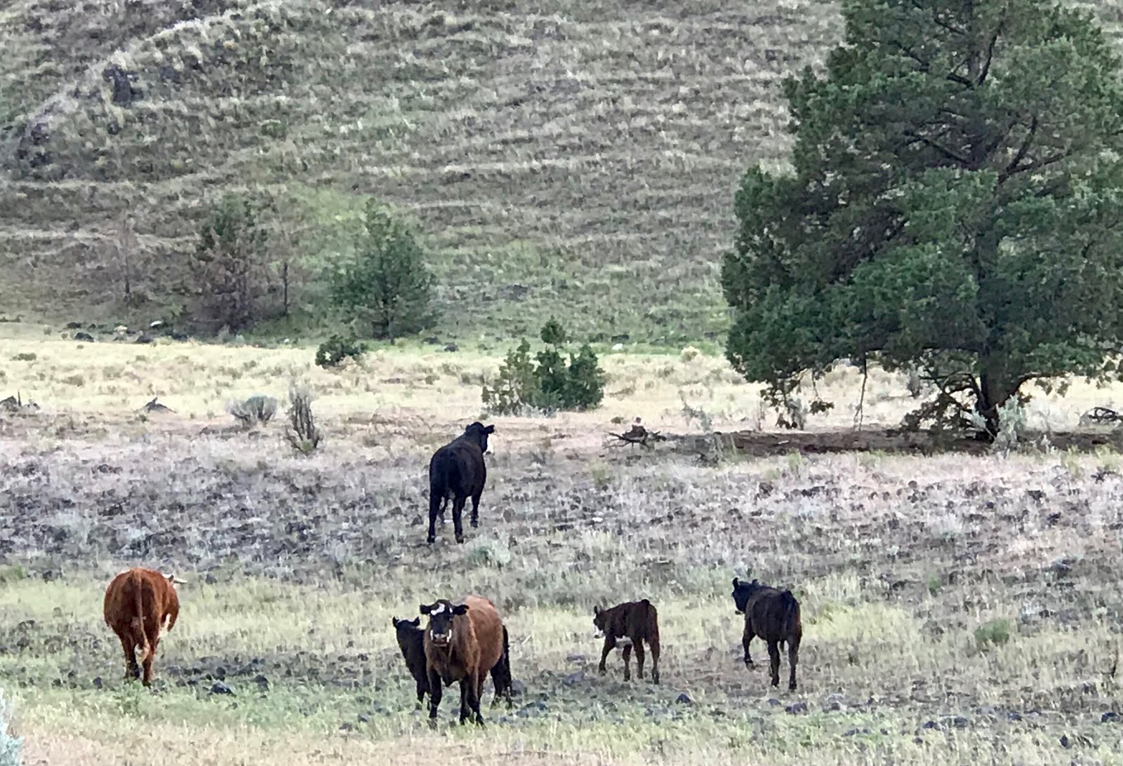
    Cattle (pic below) are a major pollution source. These guys were miffed because we took their spot our first night out. It was evident that they favored this campsite as cow pies of various ripeness were all over the place. PK and I pitched our tent not too far from a fresh pile, which we marked with a shovel, and also a red ant hill, over which we placed sticks so as not to step on it.


What's irksome about river trips
  • Getting ready - requires planning, packing and prep sometimes out of proportion to trip enjoyment.
  • Setting up our 30-year-old old Moss tent. The damn thing never wears out!
  • Lugging heavy containers up steep river banks, then down again to the raft
  • Sitting for hours at a time, even with great scenery (Even in the Grand Canyon!)
  • But the worst thing? Using the loo.
The loo is always situated in a private spot with a scenic view.

The lid opens to a plastic bag, supported by a mesh bag, with a scoop of chemical beads that somehow renders the contents acceptable for tossing into waste receptacles. 

Once closed,  the plastic bag, called a Wag Bag, joins previous days' bags in a plastic bucket with a secure lid. Then somebody gets to carry it on his or her boat. Lucky us!

Overall, this toilet system is good. Common sense and wilderness etiquette dictate that human waste — all waste— be carried out. No trace left behind, even it it comes from behind. Ha ha.

But here's the thing. Liquids are are no-no  in the loo. Instead, river trippers  pee in the surrounding area, the river, or into a can. Only solids are directed into the Wag Bag.

I find separating elimination functions problematic, as may other women past a certain age. Enough said!


Overall, this river trip leaned heavily into the pleasure category, despite the few disconcerting moments at the loo or fleeting boredom floating for hours at a time. 

    Just the dog and I were up early enough to admire the sunrise at this, our first camp of the river trip. Three nights to go. I loved this camp. Loved them all, really.

The John Day River experience reminded me that a majority of people who read my blog (thank you!)  haven't experienced self-guided wilderness river trips. Here's what it's like.

First somebody gets a river permit, or a wild hair, and sets in motion the mandatory planning and preparation, which I do not enjoy.

In our group of eight, Beth and Jeffrey had the wild hair and they instigated and led the trip. Permits are required, but anybody can get one. (On the John Day River, at least. Other river-permit applications are lotteries that disappoint the majority.)

Once a permit is secured, meals, transportation, shuttles, toilets, trash disposal, composting, water, clothing, etc. etc. must be organized, which requires people with better-than-average organizational skills.

I admire well organized people.

I'm not one, but I'm married to one, and at least four in our group could be in that category.

Beth is top dog. She has her shit together, always. On this trip, she used a 20+-year-old guidebook, plus experience with two previous trips on the John Day, to help us locate camps, petroglyphs, and keep track of historic events that had transpired along this stretch of river. Although a current guide lists 92 camps (!), few are obvious.


Beth may be addressing the wind on this blustery day.
She is unable to organize wind and weather.
Beth rows as Jeff, a fishing aficionado, tempts small mouth bass with lurid flies. He was not disappointed. The catch-and-release victims did not like the surprise, I'm guessing.

But back to the beginning.

Somebody gets the river trip urge. We plan. We pack. We drive close to 300 miles (on this trip) to the river. We look at all our stuff piled on the boat ramp. We balk.

Rafters are not minimalists. The packing-light conversation happens but does not result in restraint. Gotta have options. Right? We got em.

The put-in for our 72-mile trip on mostly flat water began at Clarno, where a bridge crosses the river and easy access is provided by the BLM, which manages the area.  According to the BLM website, one other party was putting on the river this day, but we never saw them. We had the ramp and river to ourselves


A fraction of our gear stacked up at the Clarno put-in.

What do we need for our river trip?

Everything! Including a toilet, water treatment (and/or clean water in containers from home), tents and sleeping bags, pads, food for five days, shelter in case of rain. We also bring a kitchen including stoves, Dutch ovens, charcoal, and every person's coffee-brewing device.

On a long-ago river trip, someone even brought a gasoline-powered blender to make margaritas. At least we got over that.

But I may be the worst offender since I packed clothes I never wore, food we never ate, and
a recently purchased solar panel to charge devices I never used. 

Finally we're on the river, which meanders through agricultural flat land for several miles before squeezing into scenic canyons.  In mid-May the river was still flush with snowmelt from the Strawberry Mountains, where it originates. We had strong currents, gentle wind, moderate temperatures and ideal spring conditions. By the end of June, I understand, snowmelt stops, and irrigation draws down the river until li's suitable only for canoes or kayaks. Agricultural runoff was evident even with spring flows. 

Downstream vista under a cotton tufts  sky.
What goes out of the raft must be repacked and reloaded, which requires
a couple hours each day, altogether. 
Sue and Ferron brought their dog, which fulfilled our needs for canine charm. The dog was easy to pack. I like that about well-behaved dogs. He also scarfed up leftovers.

Curry, rescued from the Curry County Animal Shelter, worries about his people.  He doesn't want to be apart from either one, hence he traipses back and forth, benefitting from their patience and skillful rowing. A reluctant swimmer, he fell in only once.
The kitchen set up includes two three-burner stoves and three tables.The tarp was erected because we'd had heavy but brief rain earlier in the day. 
PK spent hours every day performing catch and release operations on small mouth bass.
Sometimes I rowed while he fished.
I loved that Beth figured out where some hard-to-find petroglyphs
were located and led us to them, despite our doubts. 

Who were the people who survived this harsh land without
portable toilets,inflatable mattresses, and more food than they could eat?

 More resourceful than we are, no doubt. But it's unlikely any of them
lived as long as our group of mostly sixty-somethings.

Lichen decorates petroglyphs.
Margaret has been rowing for at least 30 years. Greg isn't interested, but he goes along for the ride. Near the end of the trip here, I bet he's thinking about baseball. 
We saw scarab beetles in most camps. 
Sheep in the John Day River wilderness are primarily California Big Horn sheep, which are smaller than Rocky Mountain Big Horn sheep. We saw a lot of them, including one that picked its way down an impossibly steep cliff to reach the river as we watched from our camp.

Our tent across from the cliff navigated top to bottom by a sheep.

Lichens, natural rock hues and a bit of photo enhancement give this wall a mid-day
glow. I'd love to see this in magical light - sunrise or sunset. 
A wind turbine and power towers signal we're back to civilization.
We'll see hundreds of these on our way to Moro.
Goodbye, John Day River.


Posts about earlier river experiences


Thursday, May 10, 2018

Going deeper into Patagonia - but not far enough.


A scene fit for Valentine's Day as we approached the ferry landing at Caleta Gonzalo, a tiny but hyper-busy-twice-a-day ferry port with one overnight tourist accommodation.  
Ferry rides are not optional if one intends to go south into Chilean Patagonia. Especially recently, as the major road, Carretera Austral (AKA southern route), intended to connect a chain of 17 national parks, had a massive blowout during heavy rains earlier this year necessitating a significant watery detour. 

The Carretera Austral concept of connecting parks from Pumalin Park, that begins just north of where we disembarked from the ferry, into the far reaches of southern Chile, began taking shape in the 1970s, according to this must-read National Geographic article.

In the 1970s, the  road was planned to be under 800 miles. Now the goal is 1,500 miles from Pumalin Park, where this post begins, to the far reaches of the continent near Cape Horn.

Read the article. You will want to go there. We're determined to return before we get too old, which could be coming soon.  Maybe we'll go this winter, which happens to be "summer" in Patagonia.

As a one-time-so-far traveler in Chilean Patagonia, I see the region as an adventure traveler's paradise.  It's wild, dramatic, lightly populated, rugged, gorgeous, and unique in the world. It's not luxury travel at all, unless you consider experiencing pretty much unadulterated places luxury. Which, I do. We do. 

As I write this, nearing the end of my posts about our Patagonian experiences, my longing to return grows stronger. I'm only 73. I can tackle more muddy, steep, treacherous hikes in some of the most stunning landscapes on earth. I know I can. And PK? He's not even 70 yet. No problem.

Bicyclists were everywhere in Patagonia (outside of cities). I marveled at fully loaded bicycles being leg-powered up steep roads, most dusty, graveled, and/or under construction. The light colored bike above was handmade from bamboo by its owner, a remarkable woman who was nearing the end of her solo adventure from northern South America (Colombia) to the end of the road at Cape Horn. Kate Rawles has a great story. Worth your time. 

The six-hour ferry ride through Chilean fiords was non stop gorgeous. It began in Hornoporin and ended at Caleta Gonzalo,not a town but a jumping off point to more southerly destinations,including ours, Chaiten, about 35 miles away. 
I was fascinated watching the wind press and swirl this seemingly endless cloud around a behemoth rock next to the ferry landing. Dolphins were spotted close by.
 The yellow line traces our route from Puerto Varas (a bit north of Puerto Montt) to Caleta Gonzalo to Chaiten,where we spent a night in a hostel before retracing our steps.

The yellow line on the green (Chile) on the map below represents the same area as the map above - traveling south from Puerto Montt. 

The red line traces most of our cruise. That little yellow thingie is our road trip. Obviously, we saw much more of Patagonia from the cruise ship.

Overall, we spent roughly equal time on land and sea. If I was forced at gunpoint to pick one over the other, it would be the road trip.

We could book that cruise any time. But the opportunity to travel with our son, Chris, and GF, Chelsea, may never come again.

Benefits to the pleasure of their company:
  • More randomness and surprises
  • Greater physical challenges
  • More feel for the place as we explored roads, trails and accommodations 
  • It didn't hurt that Chris speaks passable Spanish and acted as our guide.
  • It didn't hurt that they are such fun to be with.
The ferry dropped us into the Pumalin National Park, the largest private park (but open to all) in the world. It was formed by an American, Richard Tompkins, founder of North Face and Esprit brands, who purchased vast tracts of land to preserve and protect them from resource exploitation. Chile boasts numerous privately owned parks (open to the public) but Pumalin is the most recent and the largest.

Another wow moment along the road in Pumalin Park as we made our way from Caleta Gonzalo about 35 miles south to Chaiten, the closest town.

Just a few steps from the ferry landing at Caleta Gonzalo, we saw a sign we were compelled to follow: Trail to the Waterfalls is what it says. Plus a note that it takes three hours to walk to the falls and back. Three hours can be a very long time.
We got right on it. I don't know which was my worst mistake:
  • Expecting the trail to be easy. It started that way, got harder.
  • Carrying a water bottle, thus having one useless hand that could  have been clutching branches and rocks as the going got rough.
  • Not bringing a hiking pole. I should have known from previous Patagonian trails that they are never easy.
I also brought my "real" camera (not just my iPhone) The trouble with my compact Lumix Panasonic, which I love, is that it doesn't fit in my pocket. Thus another thing to carry, this one around my neck. Good thing it had a protective leather case as it banged into rocks and trees climbing short but steep trail segments.
Numerous wooden bridges eased passage over bogs and streams on Cascadas Sendero..
 This is a pleasing freeway section of the early trail 
that allows gawking without constant attention to whether 
one's next step will lead to one's injury or demise. Ok.
That's an exaggeration. This trail was hard for me because
I was carrying stuff in my hands. And because, well, it was hard.

I'd been warned that we'd encounter a stream that was high water and dangerous to cross. We reached that stream. PK and I evaluated and decided not.

Chris? He just leapt across, 50 pounds of never-left-behind camera gear on his back. He never considered not taking the leap.

Chelsea? She had issues. She's several inches shorter than Chris, not quite the leg span required. I used my Lumix Panasonic telephoto magic to capture this series.
Ummm. I don't think so.

Wait! I'll come get you!
Jump!
Not a drop of blood spilled, a foot dipped in glacial melt, nor a temporal artery popped.
Nothing to it, right?

The final trail destination, a spectacular waterfall.
Chris Korbulic photo credit. I sure didn't get far enough to see it.
Maybe with a hiking pole or a bridge .....next time.
I hope to write at least one more post about what happened between where this post ends and the completion of our Patagonian exploration. The day chronicled above ended in Chetain. After we'd rescued two bicyclists from being stranded in the dark 10 miles from town, we checked into our hostel, then ventured into the small village at 11:30 p.m. to find dinner. We couldn't believe that the recommended restaurant was packed, and that as we left close to 1 a.m., other diners were still coming in. 

Maybe it's the long daylight hours during summer in the Southern Hemisphere. Maybe it's cultural. But I gotta say, where I live, not many restaurants are open past 10 p.m. I think there's something very good about staying up late socializing. With children On week nights. How do they do it?

Experiencing and observing cultural differences are among the many marvels of international travel. 

I could write another post about time spent with Chris in more northern regions of Chile, after Chelsea left to honor work contracts. I want to do this, because it was such a great time having him show us places and introduce us to people who were important to him as he formed his plan to be a pro kayaker when he left Oregon almost 13 years ago.

But what happens with blogging-as-fun is that life gets in the way. Our Patagonia experience has been over since late January. Other remarkable, to me, anyway, stuff has gone down and I'm about to begin a series of river trips and other adventures. Not to mention a return to gardening, which I'm feeling pretty sweet about these days. After much ambivalence. 

I'm grateful to be alive.

Thanks  for reading.


Earlier posts about our South American travels

Wednesday, May 2, 2018

On the trail south in Patagonia

Along the mostly gravel road between Valle Cochamo' and Hornopiren, we had to stop often to drink in the scenery, or on the other end, relieve ourselves. Rest areas? Nada.
We left Valle Cochamo' on a blue-sky morning, traces of bright clouds adding exclamation points to our glee at diving deeper into Patagonia.  We were en route to Hornopiren, a small town and a ferry port, where the next morning we'd board a ferry bypassing a roadless area to arrive at Chaiten.

After futile attempts to book an Airbnb, or any other lodging in Hornopiren, we resorted to the old-fashioned method: drive around and hope.

Remember the days before cell phones and GPS when you schlepped from hotel to hotel trying to find an affordable vacancy? I think I still have marks in my palms from clenched fists.

It didn't take long, however, for Chris to notice a big old house with a spiffy paint job and a "rooms for rent" sign out front. A couple cottages were behind the house, and a two-bedroom unit with a tiny kitchen suited us. It cost about $50 a night.

A bonus was the stray German Shepard who hung out on the concrete step and guarded the place.

Unfortunately, not for us, but from us.

Lodging secured, by the dog and our payment, we headed for nearby Hornopiren National Park. It isn't like the national parks we know and love in the USA. In some respects, it's better: wild, untamed, undeveloped, pure wilderness.

The visitors' center was closed and didn't look like it had been open for ages. The park apparently has two trails, and the  one we were about to begin led to a mountaintop seven miles distant.


On the other hand,  the park's trails are not maintained and are inaccessible. We bumped along a few miles of gravel road through private property to reach a trail head, one of only two in the park of 186 square miles of rugged mountains and unspoiled rain forests.

The park includes two volcanoes, 12 square miles of glaciers, and huge stands of Alerce trees, somewhat comparable, in the Chilean world, to the redwood forests of Northern California.

Alerce trees and us. They will last longer. 
We didn't see Alerce trees on this hike, however. But we did experience ankle-deep mud and tripping tangles of tree roots. We feared for our osteoporotic limbs.
Really? It gets worse.
Let's go for a swim?
Loveliness distracted along the way. Although we saw few flowers.
We reached a stalemate. Chelsea scampered ahead, somehow weightless, gliding over the mess, while Chris hangs behind attempting to guide his hapless parents through the morass. We didn't last long after this stop. Neither did they. 


 We made it intact and still speaking. Still hugging, even.
Hanging on for dear life?
Back at our modest accommodation, Chris and Chelsea improvise dinner with plenty of wine on the side. Life is good! 
On the almost six-hour ferry ride the next day. OMG so beautiful! And more fun and challenge are coming. Some things it's better not to know in advance. 


Sunday, April 15, 2018

Valle Cochamo' - a private park in Patagonia

South America adventures 2018 - Episode 7
Email subscribers, please click on blog title for a better viewing experience.
Some say that Patagonia's Cochamo' Valle park, the first major stop on our road trip, is reminiscent of Yosemite National Park. Photo credit - Chelsea Behymer
We awoke in the Puerto Varas hostel, not exactly refreshed.

The kerosene fumes that about did me in the previous day had left the building, but we'd stayed up past midnight trying to hammer out an itinerary that included making reservations. Old people like to know where they might lay their heads the next night. 


The millennial people.....not that interested. But trying hard to accommodate.

PK and I were still giddy about a couple weeks on the road in Patagonian with our son and his partner, Chelsea Behymer. (I'm restraining myself from typing a row of !!!). The serendipity involved for this to occur sounds made up, but it is a true story.


Patagonia comprises the southern-most parts of Chile and Argentina. We traveled in Chile only. The terrain, unlike most of Patagonia, was cool and damp rainforest. 


Regarding accommodations, we were looking at Airbnbs, lodges and hostels. As we began our two-week journey, we had three nights booked. That was it. And also a ferry ride or two planned, I think. At least we were set for the next couple of nights.

But first things first. Trip food.

It was rainy and cool as we stopped at a supermarket on our way out of Puerto Varas. December through February is high tourist season in Chile, like summer in the USA. Most tourist areas were crowded, and traffic and parking were ridiculous in urban areas. As were scoring restaurant seating and negotiating 20-foot long lines at the supermarket.


Never mind. Our goal was to a get outta town into the wilds of Patagonia without having to hunt and gather.

We left the market with a cardboard box stuffed with salad fixings, a little salami and prosciutto, fruit, cheese, bread, peanut butter, coffee, cream, and Chilean wine. The basics.


At this lunch stop, we were reduced to mostly peanut butter. Did you know it's good with veggies and stale chocolate chip muffins? Chelsea is helping Chris dress up a carrot.
We used that same cardboard box the entire trip, avoiding as much packaging and plastic as possible. Chile is committed to recycling and conservation in a big way. But the country is not likely as committed as our traveling companions, who never intentionally buy plastic bags or plastic almost-anything.

Reuse, buy used, waste nothing.

Traffic thinned the farther away we got from Puerto Varas, and soon we were on a gravel road carrying us into the wild Patagonia I had imagined.

En route to Cochamo' we saw two young guys hitchhiking at a sharp curve along a snaking
narrow road, no shoulders, no place to pull off to pick them up. 

And who picks up hitchhikers, anyway? Chris does.


He depended on hitchhiking when he first traveled in Chile 12 years ago and "people picked me up all the time."

He jumped out to rearrange our super-sized luggage, gear and groceries stuffed under a bluetarp in the pickup bed. Space was tight, but the hitchhikers whooped at getting a ride.


Turns out they were headed to the same place we were: Valle Cochamo'.
TRANSLATION  - PLEASE READ THIS INFORMATION AND RESPECT THE INSTRUCTIONS
The Cochamo Valley is not a park or Public Reserve. From here to the border the trail passes through private property. To be able to visit, enjoy, and maintain good relations with the landowners, it is very important to respect these rules and stay on the trail. 
Like numerous parks in Chile, Cochamo' is private. That doesn't mean it's a club with
exclusive memberships, or that it costs big bucks to visit, but that the property owner takes
care of it and wants to share its beauty.
According to an August 2013 United Nations study, an impressive 308 private parks now exist throughout Chile, covering more than 1.65 million hectares (4 million acres), with more than half in the southern regions of Los Lagos, Magallanes and Los Rios. More  striking, over 200 of the parks are led by individual owners and some 60 percent are small private parks of less than 200 hectares (50 acres). From the Patagon Journal article Private Parks on the Rise, Summer 2014 issue. 
We visited several private parks, even one with a visitors' center that charged a $10 entry fee.
Cochamo' was free to hikers, but charged $15 a night for tent camping.
We stayed two nights at Campo Aventura along the Cochamo' River not far from a trailhead leading to a hanging valley six miles uphill. Once in the valley, numerous other trails provide access for campers and climbers. The large body of water on this map is a bay. The Chocamo' River is close enough to the ocean to be affected by tides.


SSpeaking of the Cochamo' River, it was just a few steps from the sweet cabins we rented for $20 a person per night, including a homemade-everything breakfast.
Of course our companions were compelled 
to take a dip in the snowmelt stream, which 
they did most days depending upon the 
presence of cold, clear water that did not
require negotiating life-threatening access.
Chelsea gloating, following a polar dip, about her foresight to grab
 a robe from the cabin, a surprising perk for a minimalist accommodation.
And a minimalist person.
.
View looking up the Cochamo' River near Campo Aventura.
To reach the cabins at Camp Aventura, we crossed a swinging bridge
and passed through a sheep pasture.
Campo Aventura is rustic. The building on the right is a common area with a wood stove and sheepskin-covered seats for hikers to warm up. We used it to prepare and enjoy our usual dinner salad and a bit of vino. Well, quite a bit.
The next day Chris and Chelsea planned to hike to the hanging valley, six miles up, and camp for the night. However, they were advised that the camping was closed as more than 1,000 people had reserved spots. What?! A thousand? Well, in that case, who wants to camp? 

They decided to go up and back in one day.

PK and I knew we didn't want to do a 12-mile hike, but set off to walk as far as we could in a few hours on the only trail to the hanging valley. Roads do not exist in the park.
Mud was ankle deep in some spots.
Trail was a trench much of the time.
We decided that the next time we're there (and we do want to return) we'll hike and 
make reservations at the lodge up top. However, we won't be too proud to hire a horse to
pack in our stuff.


It was fun seeing horses crossing the crystalline snowmelt creeks. Hikers took the swinging bridges. Photo credit....Chelsea Behymer


One of numerous swinging bridges. Horses can't use them. 
Photo credit.....Chris Korbulic

Loved the madrone-like trees near the cabins.
Also loved....
Foxgloves and fuchsia TREES dripping with blooms,along the trail.
Horses and waterfalls along the road to the trailhead.
Playful banter between Mike Rock, the caretaker/manager at Campo Aventura, and a horse packer just returning from the mountain. In the small world department, Mike had lived in Ashland, OR, not far from our home, and had guided trips on the Rogue River. He's lived in Chile for 17 years and has no plans to return north.
This is a Chilean dish that the four of us shared at a restaurant in the town, Cochamo'. We'd seen families devouring huge plates at various locations, and decided to give it a try. Wouldn't order it again, but pichanga includes sausages, hot dogs, boiled potatoes, tomatoes, boiled eggs, avocados and mozzarella cheese. In the background, is what's left of the best crab dish any of us had ever tasted, a thick cheesy soup. 


On the right, the handwritten cheque for this meal, which included a beer and a bottle of wine. With tip included, the total is around $70 USD. 

Chile is not cheap!

 It is also not a Third World country. Chris, who has traveled around the world, including most of South America, says it's his favorite.

In a future post, I want to explore why.

And also take a quick look at other places we traveled during this trip: Argentina and Uruguay.


Coming soon... finding an accommodation the old-fashioned way, and tackling another challenging trail, this one in Parque Nacional Hornopiren.