Showing posts with label Travel. Show all posts

Monday, July 26, 2021

Surprise and Inspiration in Guatemala


     I spent a brain-bending and heart-shaking couple of weeks in prepandemic NW Guatemala, February 2020, at the Maya Jaguar Educational Center (MJ). The school is an outreach of Adopt-a-Village in Guatemala (AAV). This singular organization has a dizzying but beautiful vision of restoring the Maya to self-sufficiency and self-respect through excellent education and health-giving nutrition. My time there was at once fascinating, frustrating, frightening, fun, and inspirational. 


Where is the Adopt-A-Village school?


The campus crowns a mountaintop in remote and rugged NW Guatemala an hour from the nearest village—and three full travel days from the airport in Guatemala City. It is close to the Mexican border. This aerial view includes some of the 200 acres of pristine rainforest upon which the campus has evolved for over three decades. Pristine because Founder/President Frances Dixon fenced the property and installed a locked gate at the only entry, saving the rainforest from the fate of the surrounding area where coffee plantations, cardamom fields, and wood gathering have all but destroyed the natural landscape.  

She wanted students to learn in a natural environment filled with bird songs and rainforest fragrances. Classrooms and administration buildings are on the right side of the photo, along with teachers' cabins. On the left, boys' cabins, the girls' dorm, a cafeteria/kitchen, numerous raised-bed gardens, rainwater collection tanks, outhouses, greenhouses, and a coop with 50-some chickens. 


The school's prized Toyota 4WD pick-up works as hard as any student. A driver picks up students at meeting points on roads to deliver them to the campus, where they will study for 18 consecutive days before going back to their villages for 10-12 days. In the meantime, the truck is in continuous use doing necessary bumpy and long trips to school and village operations. The truck must be replaced every two years!

Education on the Mountain

 Learning is a life-altering practice at Maya Jaguar (MJ). Although having a visitor on campus is unusual, students paid rapt attention to their biology teacher. These are older students who accept that the work they're doing in two years requires four years in public schools.

MJ's curriculum significantly surpasses educational standards established by the Guatemalan government. Regardless, these teens are committed to an education that can deliver them from poverty and servitude. So far, graduates have become nurses, teachers, and computer experts, rather than life-long field workers and 14-year-old mothers. 

 This group may look rowdy, but it's not. I was a wacky stranger encouraging     them to smile and wave for the camera as they arrived on campus for 18 days.   

Eighteen consecutive days!? Yes. Then back for 10-12 days in villages helping their parents, who initially were reluctant to release their hard-working teens for days on end. A compromise was reached; students are released to study 18 days (without a break) at MJ then return to their often distant (between a one-hour and 10-hour drive) to help the family in the coffee and cardamom fields, fetch water, gather wood, tend cooking fires, watch younger children. On and on it goes. Endless work. The same is true at the school, except the focus is on academics, plus a couple hours of chores. They rise at 5:30 a.m. and lights out at 10 p.m. 

You'd never know that the Maya Jaguar students were (or had been) disadvantaged. If I could make but one remark about the school's boarding students? 

They are the hardest-working teenagers I've ever met and the most cheerful, polite, and unjaded. And well-groomed.

Vidalia Marli Ortiz Domingo is one of them. She's wearing red in the photo below. PK and I help sponsor her education. Click here for information about donating or sponsoring.

This was Vidalia's first day at school and may have been the first time she'd slept in a sturdy building with wooden floors, flush toilets, and sinks with running water just down the hall. The dorm also has limited generator-produced electricity, but lights are on until 10 during evening study time in a commons room. Each student is supplied a solar-powered flashlight if further illumination is required. 

Vidalia and I had commonalities. Neither of us wore the traditional colorful embroidered Guatemalan clothing sported by the two other girls pictured. Me? I wore standard USA jeans and a T-shirt covered by a shawl. Plus, my usual hide-horrible-hair bandana. Vidalia wore used clothing, a boy's shirt, a plain navy skirt, and ragged ill-fitting flip-flops. She wore the same things every day. Not that any student arrived with a bag crammed with outfits. 

Other things in common? The day we arrived on campus was the first either of us had seen what is officially called the Maya Education and Developmental Center, a place I'd envisioned and longed to visit during years of volunteering for AAV.

Also, we both sucked at speaking Spanish. 

Vidalia is a native of Guatemala, a Latin American country, and she can't speak Spanish? Well, no. As a U.S. citizen attending public schools, I had more opportunities than she did to learn Spanish. Which I neglected to do, much to my regret. 

Why was Vidalia, or any other Maya youth entering the school, unable to speak the national language?

Like all the school's students, Vidalia grew up in a village speaking only Mam, one of three Mayan dialects in the area. The free public schools available to villagers do not teach the Spanish language, and teachers, by all accounts, rarely show up. Few Maya children make it through sixth grade. If they do, families must pay for mandatory school uniforms for junior and high school, which is out of the question. So Maya kids are done with any hope of schooling past age 12. Into the fields, they go. And for too many girls, on to early childbearing. Most drop out by grade three.


Learning Spanish is the first order of business and Vidalia looks as perplexed as the other newbies experiencing their initial Spanish language lesson. All classes are taught in Spanish. Talk about immersion!

It turns out that Vidalia was fortunate to be at MJ at all. Her family, more destitute than most, was in crisis. Her father had been forced off a small plot of land he believed he'd purchased with a handshake years ago. Handshake deals are common in villages where illiteracy is rampant. With scant notice, his impoverished family, including three children, was forced to vacate. He pleaded with AAV founder and president Frances Dixon to delay Vidalia's school start so the girl could help the family relocate. 

Frances said absolutely not. Not much trumps a child's needs in her view, especially a girl's urgency to be present on her first day of a real education. Frances will go off big time on the fate of uneducated indigenous females, including early childbearing, domestic violence, and life-long servitude. She's seen it all.

But Frances has a great big heart. Instead, she arranged temporary help for the family. Vidalia arrived with other students in time for her first day which included three nutritious meals packed with veggies, beans, and flavor.

           Food Matters on the Mountain

Every meal at MJ is a nutritional powerhouse. Everything on the plate was grown on campus or AAV's Educational Farm two hours distant. Every meal is homemade, and each vegetable is chopped by students during their 6 a.m. rotating chores. Every morsel is eaten, as I learned the hard way when I was late to dinner. Once.


The nutrient-packed meals are integral to AAV's mission. According to UNESCO and USAID, the Huehuetenango Department (state), where AAV is located, is the sixth-worst in the world for chronic child malnutrition, with 70 percent of young children stunted and malnourished in many villages. AAV is changing that statistic, which likely worsened during
the pandemic and the terrible storms and floods of 2020.


Below, Frances consults with master gardener Pasqual and driver Juan, not far from student housing. The raised beds and greenhouses are interspersed with boys' cabins and the girl's dorm. Every student is engaged in organic gardening.

A certificate of Organic Gardening is awarded to graduates, in addition to an academic diploma and a certificate of computer science. Perhaps best of all, students carry horticultural knowledge back to their home villages where gardens are becoming the norm. (Adult villagers may also benefit from gardening instruction at AAV's Educational Farm.)


A gardener myself, I was delighted to see all this cultivation and witness students caring for plants, including a young man using his solar flashlight to weed tomatoes around sunrise one morning. All students perform chores daily, including the hour between 6 a.m. and 7 a.m. No sleeping in for these teens.


Washing your own dishes after a meal and then returning them to the kitchen to dry is just what you do. See Vidalia learning the ropes?  A cook employee takes responsibility for the large pots required to feed 50+ people, but students are assigned to other kitchen chores, including cleaning. These are but three of 40 rainwater tanks on campus. 


Please click the link and enjoy.


         Next up - Mountain education thrives during the Pandemic. Visiting Vidalia.


Saturday, March 6, 2021

Exploring the Olympic Peninsula with Chris and Chelsea

When our son Chris and his partner Chelsea urged his restless parents to join them for winter camping and hiking on the Olympic Peninsula (OP), we practically shouted YES!, even though we'd be traveling north—into the rain. 

This has been the first winter in a half dozen that PK and I haven't fled Oregon's dismal damp by traveling south—into the sun. In recent years, we've been terribly spoiled exploring the American southwest and the Baja Peninsula in our van and then fulfilling lifelong dreams of exotic foreign travel adventures in both hemispheres.

Naturally, we've been peevish during the damn pandemic. A few quick get-aways did not remedy our high standing on the restlessness scale.

       Our guides enjoying a sweet sunrise at Lake Ozette.  
  
Chris and Chelsea live, temporarily, in their Airstream "home" close to Port Angeles, a small city on the edge of the Olympic rainshadow, where the average annual rainfall is just 26 inches. We enjoyed relatively benevolent weather as our enthusiastic guides showed off their new territory.

We saw this as we followed Chris and Chelsea in their Nevervan at the start of our tour. The weather improved in about a half-hour. 

Happy campers! The black trailer is a workspace and storage unit.
The Airstream is home-sweet-home.

Like everybody else, Chris' and Chelsea's lives were upended by the pandemic. This time of year, Chris would have been on, or planning, a kayaking expedition. Chelsea would be doubling down on her Ph.D. dissertation and preparing for another season as a cruise ship naturalist for Lindblad Expeditions-National Geographic  Instead, they migrated in the fall of 2020 to the OP from Washington's North Cascades before winter storms could hold captive the Airstream trailer they call home. 

Ramblers that they are, their intent was to stay for the winter and migrate elsewhere come spring. But it didn't take long before the OP cast a spell that has them discussing becoming first-time property owners. Their intention—and hope—is to settle near Port Angeles, the closest town to where they're now temporarily camped. 

Falling in love with the Olympic Peninsula (OP) is easy to understand. The 96-mile Strait of Juan de Fuca provides ocean perks and a gorgeous north-facing coastal strip where a handful of communities have developed.  On the south side of the coastal strip lies a great wilderness area—the  Olympic National Park. 

From the park's website:

Encompassing nearly a million acres, the park protects a vast wilderness, thousands of years of human history, and several distinctly different ecosystems, including glacier-capped mountains, old-growth temperate rain forests, and over 70 miles of wild coastline.

And kayaker Chris would add at least 19 wild rivers. With an abundance of mountains, rivers, lakes, and ocean beaches, outdoor adventures are practically unlimited. The national park alone has at least 52 trails comprising 611 trail miles. We barely scratched the surface.

If only we were younger....nevermind. 

Chris and Chelsea showed off some of their favorite places so far. Although they've only lived on the OP since October 2020, their explorations have been continuous. If you choose to visit the OP, you could do worse than follow their lead. 

SALT CREEK RECREATION AREA AND CRESCENT BAY - DO NOT MISS

A sweet sight from a coastal trail in the Salt Creek Area.


Atop the aerial photo, Crescent Bay has a private beach and is a separate entity from the official Salt Creek Recreation Area and Campground. The campsites visible accommodate large RVs requiring hook-ups. However, the wooded area between the RV camp and the bay includes some of the most desirable campsites PK and I have ever seen.

The Salt Creek Area offers stunning views from trails along the bluffs and from at least half of its campsites, many of which are fenced to prevent campers from stumbling to the ocean and rocks below. Numerous side trails and stairsteps provide access to coves, fishing rocks, and tidepools. We shared a perfect campsite with Chris and Chelsea in our respective Sprinter vans.


  A cove accessed by a steep path from a 5-mile RT trail is within the                                       Salt Creek Recreation Area. 

The area also includes the Tongue Point Marine Life Sanctuary protecting prolific tidepool creatures. (If you have time, open the link. Impressive photos!) Sadly, the tide wasn't low enough for us to navigate the pools. Another Salt Creek area highlight is significant historic World War II bunkers with interpretive signs. 

Hiking buddies posing on a lush trail.

CRESCENT BAY

Crescent Bay, adjacent to Salt Creek, is popular with - are you ready - surfers! One of whom is Chelsea, an avid type who took to the board growing up in southern California. The day we visited, maybe a dozen surfers were catching February waves, some of them likely camping at the private campground on Crescent Bay. 

Chelsea's photo of a perfect winter surfing day on Crescent Bay.

Unlike Oregon's public coastline, many Washington beaches, including the one at Crescent Bay, are private property. A parking lot off Highway 112 provides bay access for surfers and those who want to explore the adjacent rocky shore and world-class tidepools of the neighboring Salt Creek Area.

Chris is paddling out to join Chelsea, who's surfing and too far away to photograph. This spot is 15 minutes from their Airstream base. 

On another day, Chris caught Chelsea exulting on Crescent Bay.

OZETTE LAKE, DINNER IN THE RAIN, AND A BOARDWALK HIKE TO THE SEA

Ozette Lake, part of the Olympic National Park, is about a 3- hour drive from Port Angeles. We'd planned to settle into the lake's campground late in the afternoon, but problems came up: the campground was closed by flooding, rain was still falling, and darkness was closing in.

It didn't take long to determine that the campground was out. 

   But a gravel parking lot worked fine. Festive lights brightened our spirits, as did communal camp cooking.

 Good Morning Sunshine! 


That morning we set off on a 6.3-mile roundtrip cedar-boardwalk path to
the Cape Alava beach. The trail cut through a dense forest of typically lush but aggressive OP vegetation. We were awed by the work required to prevent the dense flora from eating the trail.

Hikers have options: a round-trip to the beach and back in 6.3 miles, or a 9.4-mile triangular route beginning with the boardwalk trail we hiked, then a left turn along the beach past petroglyphs, then another left onto a trail that intersects the boardwalk near the trailhead. 

We arrived at Cape Alava in time for lunch and leisurely enjoyment. Had we decided on the 9.4-mile option, we would have been rushing. I'd love to see the petroglyphs and the alternate trail back. Maybe next time.

As it was, we had time to obverse dozens of bald eagles and enjoy the
solitude, sounds, and scents of a pristine wilderness beach.
 Then on to the next great place,  Rialto Beach


RIALTO BEACH 

I've seen a lot of ocean beaches, but Rialto takes the cake for drama. Colossal Pacific Ocean waves crash onto a steep beach, which is stacked high with huge logs, more logs than we've seen on any beach anywhere.

Chelsea and Chris had visited Rialto Beach a few weeks earlier at high tide when behemoth winter waves broke onto the logs, causing them to float and crash with enormous power and racket. I wish we could have witnessed that show, but what we observed was also awe-inspiring.  

However, if you're looking for accessibility, Rialto is not good; one must first navigate the logs to walk along the beach.

Chris shot this photo of Chelsea on an earlier trip.

 PK and I on Rialto Beach in our not-meant-to-be-matching jackets and fleece-lined trousers. Chilly! The surf had calmed since the previous day.

Seastacks framed by a beached log

The rocky beach looks bland, but colorful rocks hide there.

We hung out atop a beach log and enjoyed smoked salmon, crackers, and cheese and shared a bit of wine as we watched the sky darken - not really a sunset. When we arrived at the Mora Campground just a few miles up the road, it was dark— early February kind of conditions. A light but persistent rain set in, and we made quick work of finishing a simple dinner.

BOGACHIEL RAINFOREST TRAIL 

Light rain continued the next morning, our last day on the OP. We discussed our options: get an early start home along Highway 101, which veers away from the ocean for much of the way to the Oregon border. Or hike in the rain with Chris and Chelsea on one of the national park's rainforest trails. And then start the drive south.

Hmmm. Not much of a decision. Of course, we did the hike. 

The trail follows the Bogachiel River, one of the 19 wild rivers Chris is documenting, source-to-sea, in his kayak. (More about his project below.) 

We walked for 90 minutes or so before taking a loop back to the start. The muddy trail continued along the river, likely crossing more streams with log bridges, some with handrails, some without—Chris photo credit. 

Fungi flourishing in the rainforest.

Chartreuse is a dominant rainforest hue. 

Time to say goodbye along the Bogachiel River, one of the 19 Chris is documenting in the name of conservation. Chelsea photo credit.


MORE ABOUT CHRIS AND CHELSEA 

Chris has been a professional kayaker since 2009 when Eddie Bauer offered his first sponsorship. He is also a  professional photographer and a filmmaker, writer, and conservationist. His current project: Explore and document the OP's 19 wild rivers, source to sea, supporting current proposed Washington state legislation to protect them under the national Wild and Scenic Rivers Act. (As of this writing, the House of Representatives has passed the bill, which has moved on to the Senate.)

Facebook post

One of the 19 OP rivers being proposed for protection under the
 Wild and Scenic Rivers Act. 

If you'd like to "see more," follow Chris on Facebook or Instagram

                                                            ------

A brilliant student and
 endlessly curious.

Chelsea Behymer is a determined Oregon State University Ph.D. candidate working on her dissertation and looking forward to her new seasonal job in Port Angeles. She'll guide mountain biking, canoeing paddleboarding adventures. Chelsea was a cruise ship naturalist during vacations throughout her college career, most recently with Lindblad Expeditions-National Geographic. In this photo, she's searching for wild cranberries in a rainforest meadow near Ozette Lake.


EARLIER POSTS  

Around the Horn 2018 with Chris and Chelsea - one of our best-ever  adventures 

Hoh Rainforest 2016 OP trip 

Monday, May 6, 2019

Mountains, deserts, hot springs and Las Vegas?


The Alabama Hills at sunrise in March 2017. We didn't see quite this much glory in April 2019, but you can't go wrong with the Hills. 

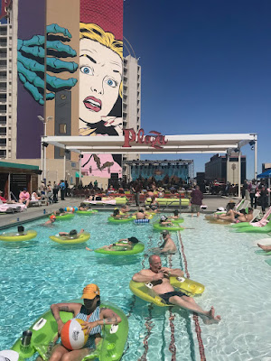
Pool venue at the music fest.

We drove our fancy van in early April to a music event - the Bender Jamboree (bluegrass) at the Plaza Hotel in Las Vegas. Yes, Las Vegas. An absurd reality, perhaps the furthest possible place from the natural world.


Although we had an engaging four-day musical experience, the road trip from Southern Oregon to Las Vegas was rich with scenic routes and side trips. And, of course, a couple days in Reno to lavish love on the grands.

We were able to spend several of those scenic-routes and side-trips explorations with hometown friends Sue Orris and Ferron Mayfield, and their worried dog, Curry.


Yes, they brought Curry to Las Vegas, but it turned out OK, even though the dog was worried about staying in the van while his people were in a hotel a block away.

Maybe that was me who was worried. Anyway, the weather was cool and Curry was fine and very well attended. No worries!

Three places stand out: Alabama Hills near Lone Pine, CA, the Shoshone and Tecopa Hot Springs area bordering Death Valley, and Red Rock National Conservation Area about 17 miles west of Las Vegas, NV. 


ALABAMA HILLS - Not to Be Missed

The Alabama Hills was our first stop after meeting up with Sue and Ferron in Bishop, CA on Hwy. 395, which cuts a pretty path alongside the scenic Sierras. Truly, if you haven't driven that road, add it to your plans. And do not miss the Alabama Hills. Even for a quick drive-through.

The Hills are just outside the town of Lone Pine, the western gateway to Death Valley National Park. 


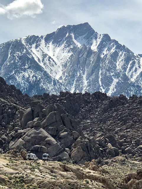
Our Class B vans are dwarfed (look for them) in
a perfect camp spot in the Alabama Hills.

Compared with nearby Death Valley's vast expanse, the Alabama Hills is a concentrated wonder. A 
jumble of giant buff-colored rocks is lorded over by the Sierra Nevada Mountains including 14,000 ft. Mt. Whitney. I used to think about climbing up there, but I got over that notion when, age-wise, I was already over the hill.

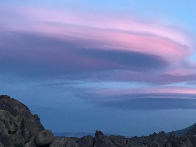
Lenticular clouds are common in the Alabama Hills. This dreamy color was fleeting during an otherwise dull sunset. 

If you've lived long enough, you've probably seen the Hills on the big screen. Over 150 movies (Some sources claim as many as 400 ) and numerous TV shows, mostly Westerns, were shot there in the days of Hopalong Cassidy, Gene Autry, and their ilk. A film museum in Lone Pine is said to be worth a visit. We will get there next time.

Responsible campers carry it out.
Alabama Hills is managed by the BLM, which means, that in addition to one fee campground, the rest of the area is absolutely FREE for dispersed camping, AKA boondocking.

Campsite hunting is competitive, with tent campers, small trailers, and Class B and C RVs seeking the perfect place to settle in and enjoy the splendid views all around. 


Sue and Ferron were in their element. Mt. Whitney is circled. The Mobius Arch Trail begins behind us.

The loop trail to the arch is about a mile long. 

Ferron exults at the Mobius Arch. A sprite-like person,  Ferron usually doesn't travel without a kite, a blaring horn, or his dog. I was pleased that he left the horn behind. 


DEATH VALLEY - Blown away

Death Valley, where we had camping reservations for two nights, was devoid of spring blooms and spring crowds. Due to the unrelenting wind and dust, it was soon devoid of us.


Serendipity at SHOSHONE and TECOPA

Thus we took an unplanned one day/night side trip to the Tecopa Hot Springs.  Our experiences there hung me up for days in getting this post out. 

Honestly, the Shoshone/Tecopa hot springs area just outside Death Valley is such a quirky bit of Wild West Americana that I got all twisted about it. I wrote pages. None of them any good!


I've decided not to tackle it. There's too much to tell and way more to learn before I pretend to capture the spirit of this unusual place. We were there for fewer than 24 hours. 

It's worth a return trip and perhaps a few days .... or more. But I'd better be careful.

Seems that numerous people living in the area had been just passing through.....and the place took hold of them. On the surface, it's dry, dusty and decrepit with scant visual charm. But there's something juicy going on there.
I didn't get his name, but the bartender/brewmaster at Death Valley Brewing was justifiably proud of the 15 or so beers being served. No wine. No liquor. Just beer. Just pizza. Crust crafted in Italy. All good. I had pineapple beer. It was delicious. 

If you're traveling from Death Valley to Las Vegas, discover Shoshone/Tecopa for yourself. Be sure to visit the museum in Shoshone, where, if lucky, you'll be greeted by John.

A former big-city chef, John is eager to share info about a place he loves. After living in Tecopa for 13 years, he knows everything tourist.

Curry contemplates as he walks the labyrinth at the Tecopa Hot Springs Resort. What is life's meaning? Why is my tongue so long? He's quite the philosopher, that dog.
Typical Tecopa scene. Curry leads Ferron in exploration. Soon we reluctantly leave Tecopa. At least I was reluctant.

RED ROCK CANYON National Conservation Area - Great side trip from Las Vegas
In Nevada's Mojave Desert, Red Rock Canyon's primary attraction, aside from an excellent Visitor's Center, is a 13-mile scenic loop drive with numerous viewpoints and parking areas from which to hike, picnic, photograph, rock climb, or otherwise take pleasure in this beautiful place. 


Here's the not-red-rock part of the conservation area, but even if not red, it is imposing, dramatic, beautiful.
Two million people visit Red Rock Canyon each year, which might keep shy persons away. But after several visits, we've learned that it doesn't take much effort to hike a mile or so on one of the 26 trails and escape the crowds. The canyon is just 17 miles west of Las Vegas and is an antidote to the madness and mayhem of the city.
Cairns for Dummies is what we called the numerous (thank you) extravagant (thank you) trail markers.  Without them, we might still be there.

Is it an agave?  Curry is weighing in from a lower position. Or maybe that's his power position.

Sue was still recovering from knee surgery, so we chose a relatively short hike through the red rocks. See that cairn? 
Without it, we would not have chosen this skinny passage.

Then, I'm afraid, it was on to Las Vegas and the Plaza Hotel and wrapping our heads around living in a casino the next four days. 

But then, there was the 
    🎶MUSIC! 🎶


BENDER JAMBOREE -whoopee!

This is Billy Strings. Never heard of him? Neither had I, but the virtuoso guitarist/singer was my favorite.  Apparently, he's getting around. Check him out. 

Other artists to join my "listen" list: 


  • Railroad Earth (not new to the list, but the primary reason we attended the Jamboree)
  • Della Mae - all female. Kicked butt!
  • Leftover Salmon
  • The Hillbenders
  • The Good Time Travelers
  • Keller Williams Pettygrass (all Tom Petty covers)
Like many music festivals, this one was crazy with costumes, theme days/nights, gregarious music lovers, spontaneous celebrations, lots of dancing, and not too much casino. 

Della Mae's band stood out amidst a mostly male lineup.
Not just for being women, but for being good!


Ferron always brings a cute outfit.

On our way home to Oregon, we camped alone at a reservoir near Fallon, NV. Ahhh. Just what we needed.


Previous Posts

SW Road Trip Spring 2017 
Death Valley 1, Super Bloom
Death Valley 2  


A couple of posts about our winter Baja trip are below. A few more to come. Unless I decide to write about gardens and food for a while.

An Inglorious Day on the Road in Baja
On the Road in Baja - Part 1